Indiana has 92 counties. The state’s county map connects the Indianapolis area with northern counties near Lake Michigan, eastern communities and the Ohio River region to the south. This guide includes a labeled Indiana county map, a state overview, the most populous counties in the 2020 Census and a complete alphabetical county list.
Indiana State Overview
Feature
Details
State Name
Indiana
State Abbreviation
IN
Capital City
Indianapolis
County-level Areas
92 counties
Population (2020 Census)
6,785,528
Land Area (2020 Census)
35,825.18 square miles
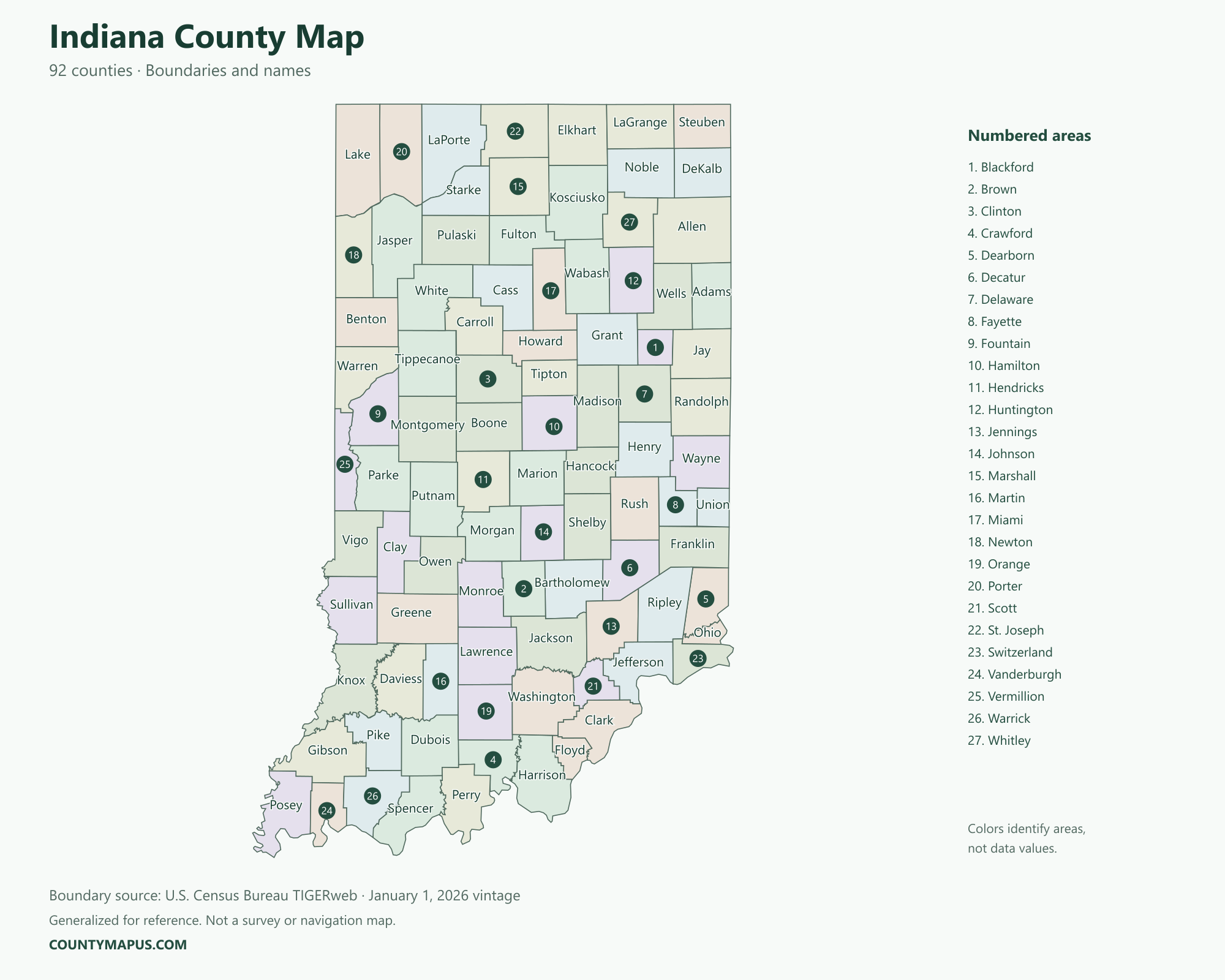
Indiana County Map
Locate a county by its name, then use its boundary to identify neighboring counties. Indianapolis is associated with Marion County, Fort Wayne with Allen County and South Bend with St. Joseph County. County names and city names can differ, so the county-seat column is useful when you know a city but not its county.
U.S. Census Bureau TIGERweb county boundaries, January 1, 2026 vintage. Colors distinguish areas; they do not represent population.
Top Counties in Indiana (Population & County Seat)
Population comparisons below use the April 1, 2020 Census. They are census counts, not current estimates. Using the same year makes the county comparisons consistent.
County / Equivalent
County Seat / Government Center
Population — 2020 Census
Marion County
Indianapolis
977,203
Lake County
Crown Point
498,700
Allen County
Fort Wayne
385,410
Hamilton County
Noblesville
347,467
St. Joseph County
South Bend
272,912
Elkhart County
Goshen
207,047
Tippecanoe County
Lafayette
186,251
The complete alphabetical list below includes all 92 county-level areas, including the 85 not shown in this population table.
Download Indiana State Map (Hi-Res)
Format
Download
PNG Map
Download Now
PDF Printable
Download Now
SVG Editable
Download Now
GIS Shapefile (ZIP)
Download Now
Full List of Indiana Counties (Alphabetical)
Adams County
Allen County
Bartholomew County
Benton County
Blackford County
Boone County
Brown County
Carroll County
Cass County
Clark County
Clay County
Clinton County
Crawford County
Daviess County
DeKalb County
Dearborn County
Decatur County
Delaware County
Dubois County
Elkhart County
Fayette County
Floyd County
Fountain County
Franklin County
Fulton County
Gibson County
Grant County
Greene County
Hamilton County
Hancock County
Harrison County
Hendricks County
Henry County
Howard County
Huntington County
Jackson County
Jasper County
Jay County
Jefferson County
Jennings County
Johnson County
Knox County
Kosciusko County
LaGrange County
LaPorte County
Lake County
Lawrence County
Madison County
Marion County
Marshall County
Martin County
Miami County
Monroe County
Montgomery County
Morgan County
Newton County
Noble County
Ohio County
Orange County
Owen County
Parke County
Perry County
Pike County
Porter County
Posey County
Pulaski County
Putnam County
Randolph County
Ripley County
Rush County
Scott County
Shelby County
Spencer County
St. Joseph County
Starke County
Steuben County
Sullivan County
Switzerland County
Tippecanoe County
Tipton County
Union County
Vanderburgh County
Vermillion County
Vigo County
Wabash County
Warren County
Warrick County
Washington County
Wayne County
Wells County
White County
Whitley County
FAQs: Indiana Counties
❓ How many counties are in Indiana? Indiana has 92 counties. All county-level areas are identified on this map.
❓ What is the capital of Indiana? Indianapolis is the state capital.
❓ Which county had the largest population in the 2020 Census? Marion County had 977,203 residents in the 2020 Census. Its county seat or government center is Indianapolis.
❓ What is the largest county in Indiana by land area? Allen County has the greatest land area in the Census boundary dataset. Land area and population rankings measure different things.
❓ What county is Indianapolis in? Indianapolis is in Marion County. It is Indiana’s capital and Marion County’s county seat.
❓ What county is Fort Wayne in? Fort Wayne is in Allen County and serves as its county seat.
❓ What county is South Bend in? South Bend is the county seat of St. Joseph County.
❓ Is the city of Marion in Marion County? No. The city of Marion is in Grant County. Marion County’s county seat is Indianapolis.
❓ How should I use this county map? Use a county name or a known county seat to identify the area, then follow its boundary to neighboring counties. City limits and county boundaries are different. This reference map does not show property lines or road navigation.