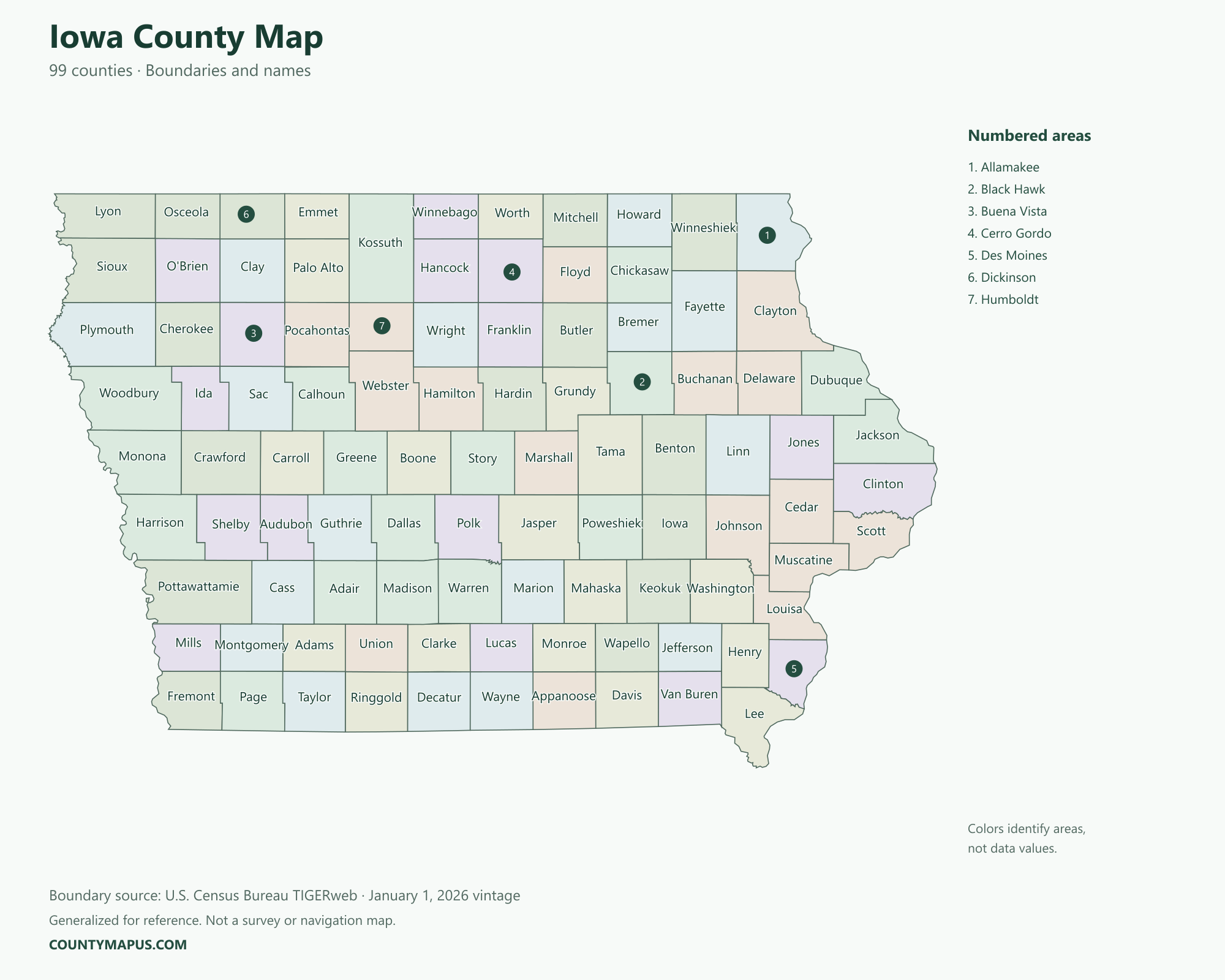
Iowa has 99 counties, from the Missouri River side of the state to the Mississippi River side. The Iowa county map below identifies county boundaries and names and provides context for Des Moines, Cedar Rapids, Davenport, Iowa City and other county seats. Population comparisons use the 2020 Census rather than mixing estimates from different years.
Iowa State Overview
Feature
Details
State Name
Iowa
State Abbreviation
IA
Capital City
Des Moines
County-level Areas
99 counties
Population (2020 Census)
3,190,369
Land Area (2020 Census)
55,853.72 square miles
Iowa County Map
Much of Iowa’s county pattern is regular, but boundaries along the state’s river edges are less uniform. Find a county name on the map or in the alphabetical list, then use the county-seat table to connect the county with a familiar city. A county seat is not necessarily the largest city in every county.
U.S. Census Bureau TIGERweb county boundaries, January 1, 2026 vintage. Colors distinguish areas; they do not represent population.
Top Counties in Iowa (Population & County Seat)
Population comparisons below use the April 1, 2020 Census. They are census counts, not current estimates. Using the same year makes the county comparisons consistent.
County / Equivalent
County Seat / Government Center
Population — 2020 Census
Polk County
Des Moines
492,401
Linn County
Cedar Rapids
230,299
Scott County
Davenport
174,669
Johnson County
Iowa City
152,854
Black Hawk County
Waterloo
131,144
Woodbury County
Sioux City
105,941
Dallas County
Adel
99,678
The complete alphabetical list below includes all 99 county-level areas, including the 92 not shown in this population table.
Download Iowa State Map (Hi-Res)
Format
Download
PNG Map
Download Now
PDF Printable
Download Now
SVG Editable
Download Now
GIS Shapefile (ZIP)
Download Now
Full List of Iowa Counties (Alphabetical)
Adair County
Adams County
Allamakee County
Appanoose County
Audubon County
Benton County
Black Hawk County
Boone County
Bremer County
Buchanan County
Buena Vista County
Butler County
Calhoun County
Carroll County
Cass County
Cedar County
Cerro Gordo County
Cherokee County
Chickasaw County
Clarke County
Clay County
Clayton County
Clinton County
Crawford County
Dallas County
Davis County
Decatur County
Delaware County
Des Moines County
Dickinson County
Dubuque County
Emmet County
Fayette County
Floyd County
Franklin County
Fremont County
Greene County
Grundy County
Guthrie County
Hamilton County
Hancock County
Hardin County
Harrison County
Henry County
Howard County
Humboldt County
Ida County
Iowa County
Jackson County
Jasper County
Jefferson County
Johnson County
Jones County
Keokuk County
Kossuth County
Lee County
Linn County
Louisa County
Lucas County
Lyon County
Madison County
Mahaska County
Marion County
Marshall County
Mills County
Mitchell County
Monona County
Monroe County
Montgomery County
Muscatine County
O'Brien County
Osceola County
Page County
Palo Alto County
Plymouth County
Pocahontas County
Polk County
Pottawattamie County
Poweshiek County
Ringgold County
Sac County
Scott County
Shelby County
Sioux County
Story County
Tama County
Taylor County
Union County
Van Buren County
Wapello County
Warren County
Washington County
Wayne County
Webster County
Winnebago County
Winneshiek County
Woodbury County
Worth County
Wright County
FAQs: Iowa Counties
❓ How many counties are in Iowa? Iowa has 99 counties. All county-level areas are identified on this map.
❓ What is the capital of Iowa? Des Moines is the state capital.
❓ Which county had the largest population in the 2020 Census? Polk County had 492,401 residents in the 2020 Census. Its county seat or government center is Des Moines.
❓ What is the largest county in Iowa by land area? Kossuth County has the greatest land area in the Census boundary dataset. Land area and population rankings measure different things.
❓ What county is Des Moines in? Des Moines is Iowa’s capital and the county seat of Polk County.
❓ What county is Cedar Rapids in? Cedar Rapids is the county seat of Linn County.
❓ What county is Davenport in? Davenport is in Scott County and serves as its county seat.
❓ What county is Iowa City in? Iowa City is the county seat of Johnson County. The city name should not be confused with Iowa County, a separate county.
❓ How should I use this county map? Use a county name or a known county seat to identify the area, then follow its boundary to neighboring counties. City limits and county boundaries are different. This reference map does not show property lines or road navigation.