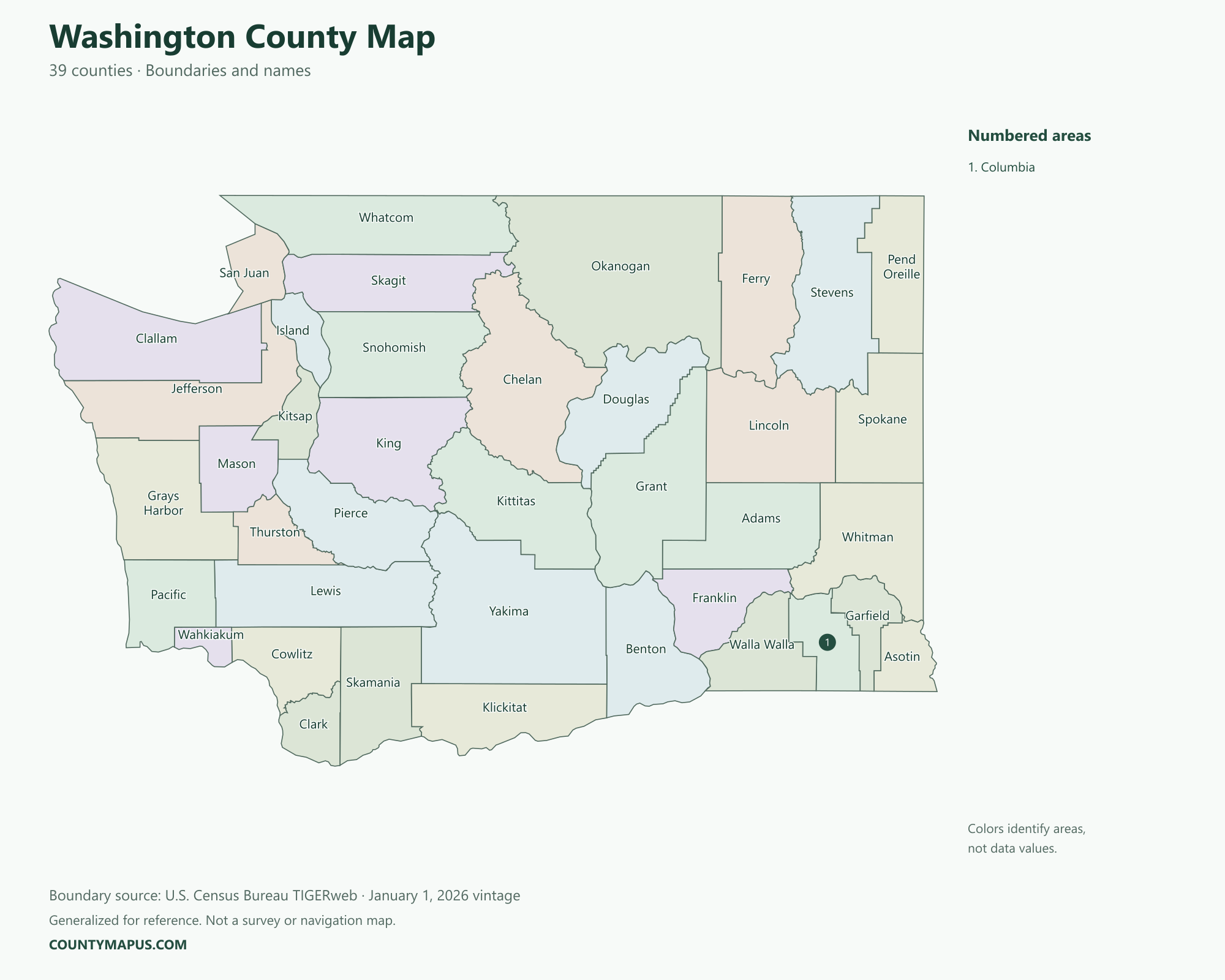
Washington state has 39 counties. The county map covers the Pacific Coast, Puget Sound region, Cascade Mountains and eastern Washington. Use it to place Seattle, Tacoma, Everett, Spokane, Vancouver and Olympia in their county context. Washington state is distinct from Washington, D.C.; this guide covers the Pacific Northwest state.
Washington State Overview
Feature
Details
State Name
Washington
State Abbreviation
WA
Capital City
Olympia
County-level Areas
39 counties
Population (2020 Census)
7,705,281
Land Area (2020 Census)
66,456.57 square miles
Washington County Map
The Cascade region separates many western and eastern county areas. Islands and coastal inlets can make some western boundaries more complex. The map labels every county, using numbered callouts where names would overlap. County seats connect the geographic areas with their principal government centers.
U.S. Census Bureau TIGERweb county boundaries, January 1, 2026 vintage. Colors distinguish areas; they do not represent population.
Top Counties in Washington (Population & County Seat)
Population comparisons below use the April 1, 2020 Census. They are census counts, not current estimates. Using the same year makes the county comparisons consistent.
County / Equivalent
County Seat / Government Center
Population — 2020 Census
King County
Seattle
2,269,675
Pierce County
Tacoma
921,130
Snohomish County
Everett
827,957
Spokane County
Spokane
539,339
Clark County
Vancouver
503,311
Thurston County
Olympia
294,793
Kitsap County
Port Orchard
275,611
The complete alphabetical list below includes all 39 county-level areas, including the 32 not shown in this population table.
Download Washington State Map (Hi-Res)
Format
Download
PNG Map
Download Now
PDF Printable
Download Now
SVG Editable
Download Now
GIS Shapefile (ZIP)
Download Now
Full List of Washington Counties (Alphabetical)
Adams County
Asotin County
Benton County
Chelan County
Clallam County
Clark County
Columbia County
Cowlitz County
Douglas County
Ferry County
Franklin County
Garfield County
Grant County
Grays Harbor County
Island County
Jefferson County
King County
Kitsap County
Kittitas County
Klickitat County
Lewis County
Lincoln County
Mason County
Okanogan County
Pacific County
Pend Oreille County
Pierce County
San Juan County
Skagit County
Skamania County
Snohomish County
Spokane County
Stevens County
Thurston County
Wahkiakum County
Walla Walla County
Whatcom County
Whitman County
Yakima County
FAQs: Washington Counties
❓ How many counties are in Washington? Washington has 39 counties. All county-level areas are identified on this map.
❓ What is the capital of Washington? Olympia is the state capital.
❓ Which county had the largest population in the 2020 Census? King County had 2,269,675 residents in the 2020 Census. Its county seat or government center is Seattle.
❓ What is the largest county in Washington by land area? Okanogan County has the greatest land area in the Census boundary dataset. Land area and population rankings measure different things.
❓ What county is Seattle in? Seattle is the county seat of King County.
❓ What county is Tacoma in? Tacoma is in Pierce County and serves as its county seat.
❓ What county is Olympia in? Olympia is Washington’s capital and the county seat of Thurston County.
❓ What county is Vancouver, Washington in? Vancouver, Washington is the county seat of Clark County. It is a different city from Vancouver in British Columbia, Canada.
❓ How should I use this county map? Use a county name or a known county seat to identify the area, then follow its boundary to neighboring counties. City limits and county boundaries are different. This reference map does not show property lines or road navigation.