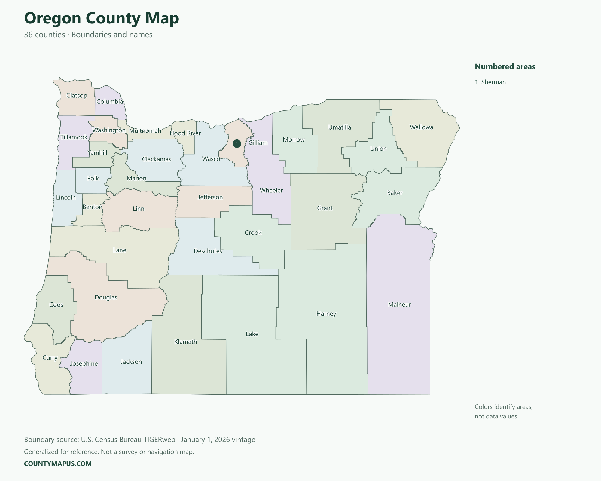
Oregon has 36 counties, spanning the Pacific Coast, Willamette Valley, Cascade region and eastern Oregon. This county map places Portland, Salem, Eugene, Medford and Bend in their wider county geography. The guide includes labeled boundaries, county seats, 2020 Census population comparisons and the complete county list.
Oregon State Overview
Feature
Details
State Name
Oregon
State Abbreviation
OR
Capital City
Salem
County-level Areas
36 counties
Population (2020 Census)
4,237,256
Land Area (2020 Census)
95,996.87 square miles
Oregon County Map
County sizes vary substantially across Oregon. Eastern counties often cover large land areas, while several western counties are smaller and more densely populated. Portland is primarily associated with Multnomah County, but its municipal limits also extend into Washington and Clackamas counties. The map shows county boundaries, not those city limits.
U.S. Census Bureau TIGERweb county boundaries, January 1, 2026 vintage. Colors distinguish areas; they do not represent population.
Top Counties in Oregon (Population & County Seat)
Population comparisons below use the April 1, 2020 Census. They are census counts, not current estimates. Using the same year makes the county comparisons consistent.
County / Equivalent
County Seat / Government Center
Population — 2020 Census
Multnomah County
Portland
815,428
Washington County
Hillsboro
600,372
Clackamas County
Oregon City
421,401
Lane County
Eugene
382,971
Marion County
Salem
345,920
Jackson County
Medford
223,259
Deschutes County
Bend
198,253
The complete alphabetical list below includes all 36 county-level areas, including the 29 not shown in this population table.
Download Oregon State Map (Hi-Res)
Format
Download
PNG Map
Download Now
PDF Printable
Download Now
SVG Editable
Download Now
GIS Shapefile (ZIP)
Download Now
Full List of Oregon Counties (Alphabetical)
Baker County
Benton County
Clackamas County
Clatsop County
Columbia County
Coos County
Crook County
Curry County
Deschutes County
Douglas County
Gilliam County
Grant County
Harney County
Hood River County
Jackson County
Jefferson County
Josephine County
Klamath County
Lake County
Lane County
Lincoln County
Linn County
Malheur County
Marion County
Morrow County
Multnomah County
Polk County
Sherman County
Tillamook County
Umatilla County
Union County
Wallowa County
Wasco County
Washington County
Wheeler County
Yamhill County
FAQs: Oregon Counties
❓ How many counties are in Oregon? Oregon has 36 counties. All county-level areas are identified on this map.
❓ What is the capital of Oregon? Salem is the state capital.
❓ Which county had the largest population in the 2020 Census? Multnomah County had 815,428 residents in the 2020 Census. Its county seat or government center is Portland.
❓ What is the largest county in Oregon by land area? Harney County has the greatest land area in the Census boundary dataset. Land area and population rankings measure different things.
❓ What county is Salem associated with? Salem is Oregon’s capital and the county seat of Marion County. The city also extends into Polk County.
❓ What county is Eugene in? Eugene is in Lane County and serves as its county seat.
❓ What county is Bend in? Bend is the county seat of Deschutes County.
❓ What county is Medford in? Medford is in Jackson County and is its county seat.
❓ How should I use this county map? Use a county name or a known county seat to identify the area, then follow its boundary to neighboring counties. City limits and county boundaries are different. This reference map does not show property lines or road navigation.