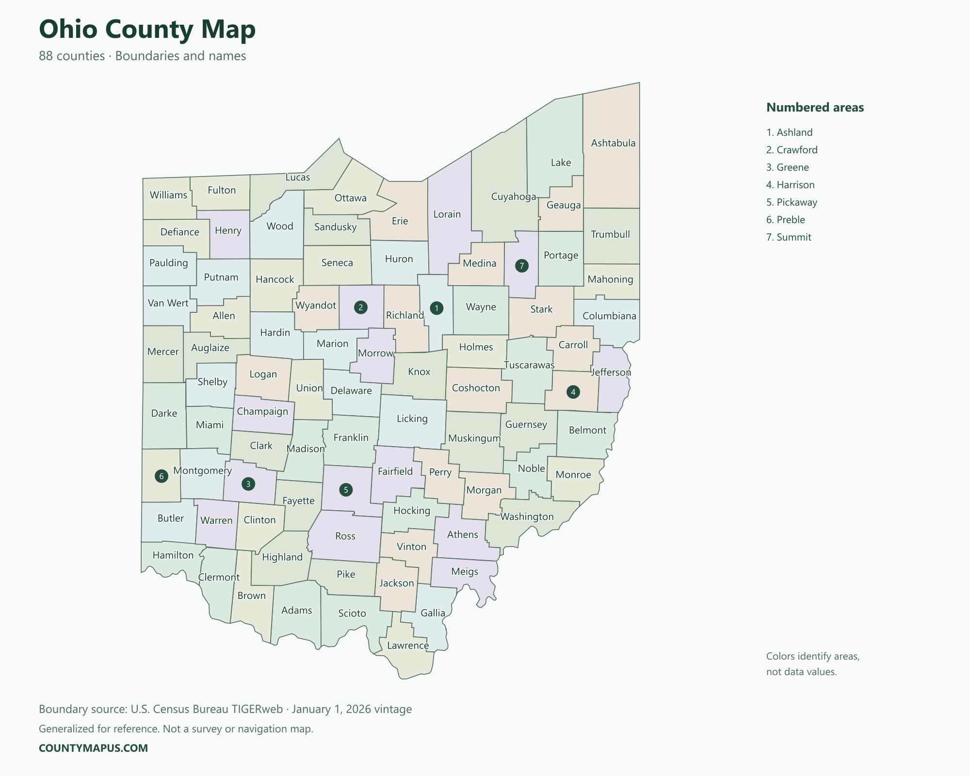
Ohio has 88 counties. The county map links the Lake Erie region, central Ohio, western communities and the Ohio River border. Use the labeled boundaries to find the counties associated with Columbus, Cleveland, Cincinnati, Akron and Dayton. The tables below give county seats and population figures from the 2020 Census.
Ohio State Overview
Feature
Details
State Name
Ohio
State Abbreviation
OH
Capital City
Columbus
County-level Areas
88 counties
Population (2020 Census)
11,799,448
Land Area (2020 Census)
40,859.09 square miles
Ohio County Map
Ohio city names and county names do not always match. Cincinnati is the county seat of Hamilton County, while the city of Hamilton is the county seat of Butler County. The map identifies county boundaries rather than city limits, making it useful for locating a county before looking up local data.
U.S. Census Bureau TIGERweb county boundaries, January 1, 2026 vintage. Colors distinguish areas; they do not represent population.
Top Counties in Ohio (Population & County Seat)
Population comparisons below use the April 1, 2020 Census. They are census counts, not current estimates. Using the same year makes the county comparisons consistent.
County / Equivalent
County Seat / Government Center
Population — 2020 Census
Franklin County
Columbus
1,323,807
Cuyahoga County
Cleveland
1,264,817
Hamilton County
Cincinnati
830,639
Summit County
Akron
540,428
Montgomery County
Dayton
537,309
Lucas County
Toledo
431,279
Butler County
Hamilton
390,357
The complete alphabetical list below includes all 88 county-level areas, including the 81 not shown in this population table.
Download Ohio State Map (Hi-Res)
Format
Download
PNG Map
Download Now
PDF Printable
Download Now
SVG Editable
Download Now
GIS Shapefile (ZIP)
Download Now
Full List of Ohio Counties (Alphabetical)
Adams County
Allen County
Ashland County
Ashtabula County
Athens County
Auglaize County
Belmont County
Brown County
Butler County
Carroll County
Champaign County
Clark County
Clermont County
Clinton County
Columbiana County
Coshocton County
Crawford County
Cuyahoga County
Darke County
Defiance County
Delaware County
Erie County
Fairfield County
Fayette County
Franklin County
Fulton County
Gallia County
Geauga County
Greene County
Guernsey County
Hamilton County
Hancock County
Hardin County
Harrison County
Henry County
Highland County
Hocking County
Holmes County
Huron County
Jackson County
Jefferson County
Knox County
Lake County
Lawrence County
Licking County
Logan County
Lorain County
Lucas County
Madison County
Mahoning County
Marion County
Medina County
Meigs County
Mercer County
Miami County
Monroe County
Montgomery County
Morgan County
Morrow County
Muskingum County
Noble County
Ottawa County
Paulding County
Perry County
Pickaway County
Pike County
Portage County
Preble County
Putnam County
Richland County
Ross County
Sandusky County
Scioto County
Seneca County
Shelby County
Stark County
Summit County
Trumbull County
Tuscarawas County
Union County
Van Wert County
Vinton County
Warren County
Washington County
Wayne County
Williams County
Wood County
Wyandot County
FAQs: Ohio Counties
❓ How many counties are in Ohio? Ohio has 88 counties. All county-level areas are identified on this map.
❓ What is the capital of Ohio? Columbus is the state capital.
❓ Which county had the largest population in the 2020 Census? Franklin County had 1,323,807 residents in the 2020 Census. Its county seat or government center is Columbus.
❓ What is the largest county in Ohio by land area? Ashtabula County has the greatest land area in the Census boundary dataset. Land area and population rankings measure different things.
❓ What county is Columbus associated with? Columbus is Ohio’s capital and the county seat of Franklin County. The city also extends into Delaware and Fairfield counties.
❓ What county is Cleveland in? Cleveland is the county seat of Cuyahoga County.
❓ What county is Cincinnati in? Cincinnati is in Hamilton County and serves as its county seat.
❓ Are Hamilton County and the city of Hamilton the same place? No. Hamilton County’s county seat is Cincinnati. The city of Hamilton is in Butler County and is Butler County’s county seat.
❓ How should I use this county map? Use a county name or a known county seat to identify the area, then follow its boundary to neighboring counties. City limits and county boundaries are different. This reference map does not show property lines or road navigation.