Colorado has 64 counties, stretching from the Rocky Mountains and Western Slope to the Front Range and eastern plains. Use this Colorado county map to locate county boundaries, compare county names, and find major county seats such as Denver, Colorado Springs, Golden and Fort Collins. Below you will find a state overview, a labeled county map, population comparisons and the complete alphabetical county list.
Colorado State Overview
Feature
Details
State Name
Colorado
State Abbreviation
CO
Capital City
Denver
Total Counties
64
State Nickname
Centennial State
Statehood
August 1, 1876 — 38th state
Population (2020 Census)
5,773,714
Land Area (2020 Census)
103,637.06 square miles
Colorado County Map
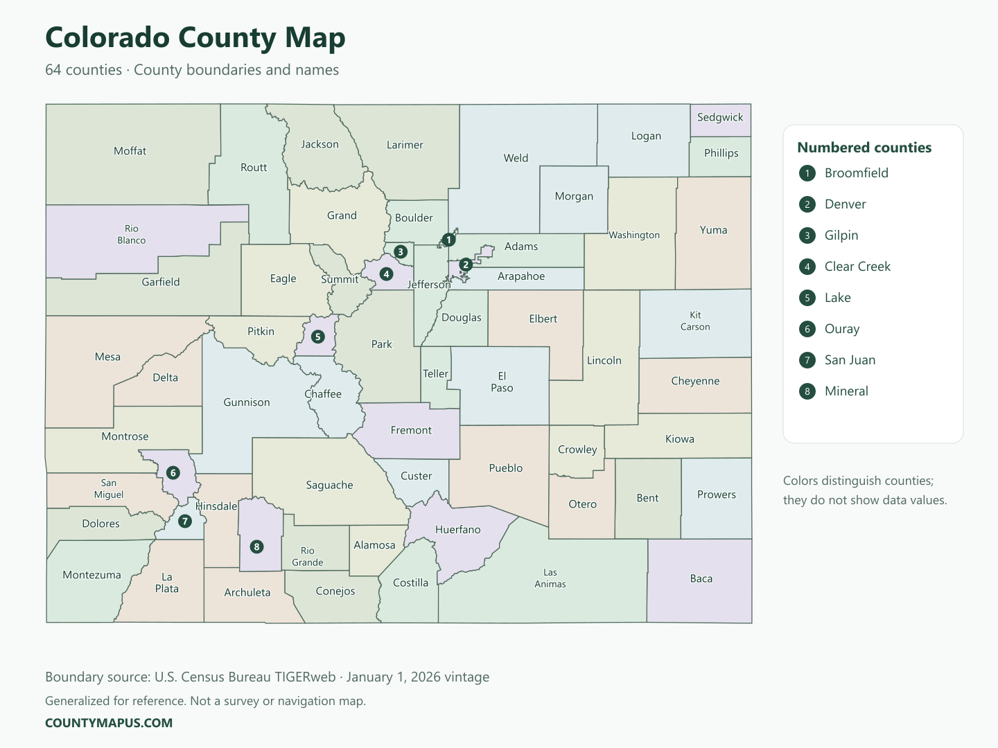
The map shows all 64 counties with their boundaries and names. Numbered labels identify smaller counties where a full name would be difficult to read. Denver is the state capital, and Colorado Springs is the county seat of El Paso County. County boundaries differ from city limits, so a city name and a county name are not always interchangeable.
Colorado county boundaries: U.S. Census Bureau TIGERweb, January 1, 2026 vintage. Colors distinguish counties, not population or other data values.
Top Counties in Colorado (Population & County Seat)
These are Colorado’s seven most populous counties in the April 1, 2020 Census. The figures are census counts rather than current population estimates; using one reference year makes the counties comparable.
County
County Seat
Population — 2020 Census
El Paso County
Colorado Springs
730,395
Denver County
Denver
715,522
Arapahoe County
Littleton
655,070
Jefferson County
Golden
582,910
Adams County
Brighton
519,572
Larimer County
Fort Collins
359,066
Douglas County
Castle Rock
357,978
Colorado has 57 more counties. The full alphabetical list appears below. Larger population does not mean larger land area: Las Animas County has the greatest land area, while El Paso County had the largest population in the 2020 Census.
Download Colorado State Map (Hi-Res)
Format
Download
PNG Map
Download Now
PDF Printable
Download Now
SVG Editable
Download Now
GIS Shapefile (ZIP)
Download Now
Full List of Colorado Counties (Alphabetical)
Adams County
Alamosa County
Arapahoe County
Archuleta County
Baca County
Bent County
Boulder County
Broomfield County
Chaffee County
Cheyenne County
Clear Creek County
Conejos County
Costilla County
Crowley County
Custer County
Delta County
Denver County
Dolores County
Douglas County
Eagle County
El Paso County
Elbert County
Fremont County
Garfield County
Gilpin County
Grand County
Gunnison County
Hinsdale County
Huerfano County
Jackson County
Jefferson County
Kiowa County
Kit Carson County
La Plata County
Lake County
Larimer County
Las Animas County
Lincoln County
Logan County
Mesa County
Mineral County
Moffat County
Montezuma County
Montrose County
Morgan County
Otero County
Ouray County
Park County
Phillips County
Pitkin County
Prowers County
Pueblo County
Rio Blanco County
Rio Grande County
Routt County
Saguache County
San Juan County
San Miguel County
Sedgwick County
Summit County
Teller County
Washington County
Weld County
Yuma County
FAQs: Colorado Counties
❓ How many counties are in Colorado? Colorado has 64 counties. The county map and alphabetical list above include all 64.
❓ What is the capital of Colorado? Denver is Colorado’s capital. It is shown separately from neighboring Adams, Arapahoe and Jefferson counties on the county map.
❓ Which Colorado county has the largest population? El Paso County had 730,395 residents in the 2020 Census, making it the most populous county in that census. Its county seat is Colorado Springs.
❓ What is the largest county in Colorado by land area? Las Animas County is Colorado’s largest county by land area. Population rankings and land-area rankings describe different things.
❓ What county is Colorado Springs in? Colorado Springs is in El Paso County and serves as its county seat.
❓ What county is Fort Collins in? Fort Collins is in Larimer County and is its county seat.
❓ What county is Boulder in? Boulder is in Boulder County. Boulder County’s county seat is also Boulder.
❓ How should I use a Colorado county map? Start with a county name or a known county seat, then use the boundaries to identify nearby counties. This map is suitable for geographic reference and learning; it does not show property lines, road navigation or survey measurements.
County boundaries use U.S. Census Bureau TIGERweb, January 1, 2026 vintage, generalized for this reference map. County population figures use 2020 Census county counts. County seats are checked against the Colorado county-seat dataset. State population and land area are from Census QuickFacts; statehood and capital are documented by the Library of Congress. Different dates describe different datasets; the 2020 population figures are not presented as 2026 estimates.
Newsletter Updates
Enter your email address below and subscribe to our newsletter