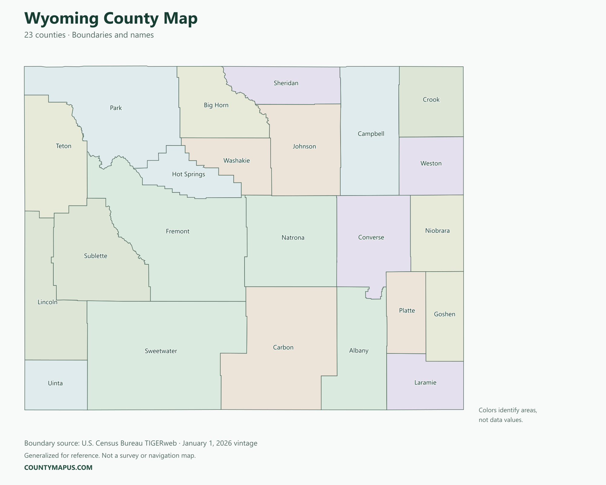
Wyoming has 23 counties. The county map connects mountain regions, basins and plains with county seats such as Cheyenne, Casper, Gillette, Green River and Lander. The guide includes labeled county boundaries, 2020 Census population figures and a complete alphabetical county list.
Wyoming State Overview
Feature
Details
State Name
Wyoming
State Abbreviation
WY
Capital City
Cheyenne
County-level Areas
23 counties
Population (2020 Census)
576,851
Land Area (2020 Census)
97,088.55 square miles
Wyoming County Map
Wyoming counties can cover large geographic areas with relatively small populations. The largest county by land area need not be the most populous. Another common point of confusion is Laramie: the city of Laramie is in Albany County, while Laramie County’s county seat is Cheyenne.
U.S. Census Bureau TIGERweb county boundaries, January 1, 2026 vintage. Colors distinguish areas; they do not represent population.
Top Counties in Wyoming (Population & County Seat)
Population comparisons below use the April 1, 2020 Census. They are census counts, not current estimates. Using the same year makes the county comparisons consistent.
County / Equivalent
County Seat / Government Center
Population — 2020 Census
Laramie County
Cheyenne
100,512
Natrona County
Casper
79,955
Campbell County
Gillette
47,026
Sweetwater County
Green River
42,272
Fremont County
Lander
39,234
Albany County
Laramie
37,066
Sheridan County
Sheridan
30,921
The complete alphabetical list below includes all 23 county-level areas, including the 16 not shown in this population table.
Download Wyoming State Map (Hi-Res)
Format
Download
PNG Map
Download Now
PDF Printable
Download Now
SVG Editable
Download Now
GIS Shapefile (ZIP)
Download Now
Full List of Wyoming Counties (Alphabetical)
Albany County
Big Horn County
Campbell County
Carbon County
Converse County
Crook County
Fremont County
Goshen County
Hot Springs County
Johnson County
Laramie County
Lincoln County
Natrona County
Niobrara County
Park County
Platte County
Sheridan County
Sublette County
Sweetwater County
Teton County
Uinta County
Washakie County
Weston County
FAQs: Wyoming Counties
❓ How many counties are in Wyoming? Wyoming has 23 counties. All county-level areas are identified on this map.
❓ What is the capital of Wyoming? Cheyenne is the state capital.
❓ Which county had the largest population in the 2020 Census? Laramie County had 100,512 residents in the 2020 Census. Its county seat or government center is Cheyenne.
❓ What is the largest county in Wyoming by land area? Sweetwater County has the greatest land area in the Census boundary dataset. Land area and population rankings measure different things.
❓ What county is Cheyenne in? Cheyenne is Wyoming’s capital and the county seat of Laramie County.
❓ Is the city of Laramie in Laramie County? No. The city of Laramie is in Albany County and is its county seat. Cheyenne is the county seat of Laramie County.
❓ What county is Casper in? Casper is the county seat of Natrona County.
❓ What county is Gillette in? Gillette is in Campbell County and serves as its county seat.
❓ How should I use this county map? Use a county name or a known county seat to identify the area, then follow its boundary to neighboring counties. City limits and county boundaries are different. This reference map does not show property lines or road navigation.