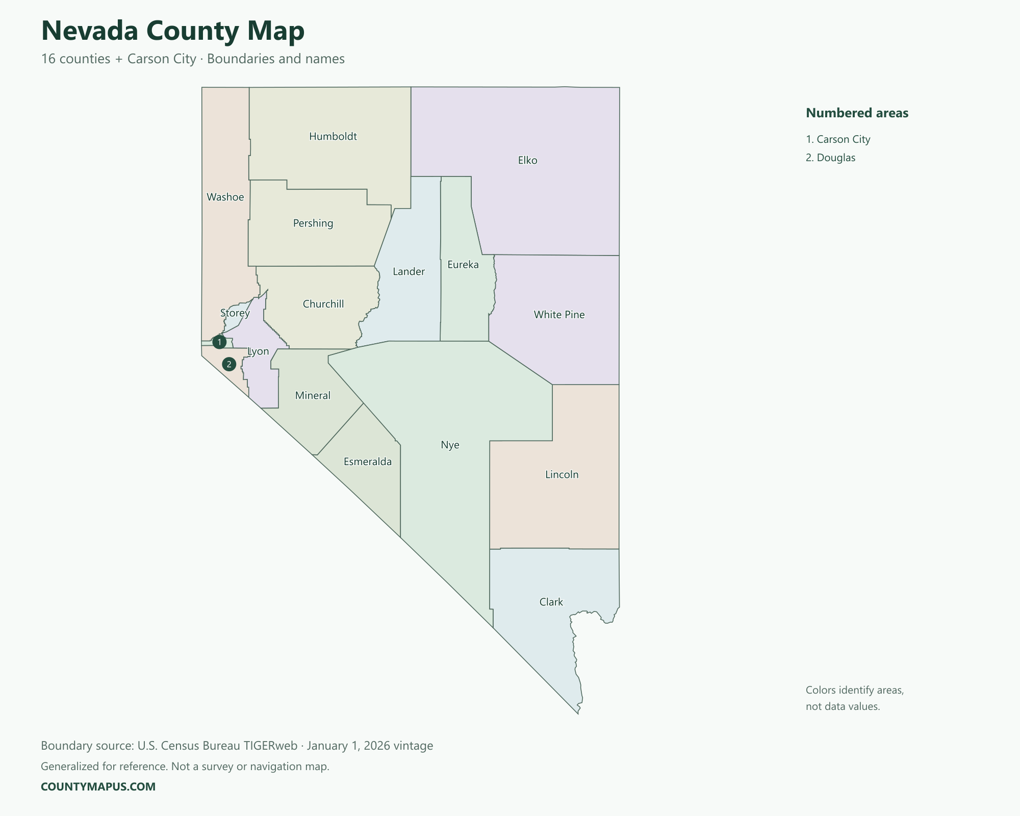
Nevada has 16 counties plus Carson City, an independent city treated as a county equivalent by the Census Bureau. This map therefore shows 17 county-level areas. Use it to locate Las Vegas in Clark County, Reno in Washoe County and the state capital at Carson City, along with Nevada’s large rural counties.
Nevada State Overview
Feature
Details
State Name
Nevada
State Abbreviation
NV
Capital City
Carson City
County-level Areas
16 counties + Carson City
Population (2020 Census)
3,104,614
Land Area (2020 Census)
109,860.38 square miles
Nevada County Map
Carson City appears on the map and in the alphabetical list without the word County. It is an independent city and county equivalent, not a seventeenth named county. The larger county areas make land-area comparisons particularly useful; they do not imply that the largest county has the most residents.
U.S. Census Bureau TIGERweb county boundaries, January 1, 2026 vintage. Colors distinguish areas; they do not represent population.
Top Counties in Nevada (Population & County Seat)
Population comparisons below use the April 1, 2020 Census. They are census counts, not current estimates. Using the same year makes the county comparisons consistent.
County / Equivalent
County Seat / Government Center
Population — 2020 Census
Clark County
Las Vegas
2,265,461
Washoe County
Reno
486,492
Lyon County
Yerington
59,235
Carson City
Carson City
58,639
Elko County
Elko
53,702
Nye County
Tonopah
51,591
Douglas County
Minden
49,488
The complete alphabetical list below includes all 17 county-level areas, including the 10 not shown in this population table.
Download Nevada State Map (Hi-Res)
Format
Download
PNG Map
Download Now
PDF Printable
Download Now
SVG Editable
Download Now
GIS Shapefile (ZIP)
Download Now
Full List of Nevada Counties & Carson City (Alphabetical)
Carson City
Churchill County
Clark County
Douglas County
Elko County
Esmeralda County
Eureka County
Humboldt County
Lander County
Lincoln County
Lyon County
Mineral County
Nye County
Pershing County
Storey County
Washoe County
White Pine County
FAQs: Nevada Counties
❓ How many counties are in Nevada? Nevada has 16 counties plus Carson City, an independent city and county equivalent. All county-level areas are identified on this map.
❓ What is the capital of Nevada? Carson City is the state capital.
❓ Which county had the largest population in the 2020 Census? Clark County had 2,265,461 residents in the 2020 Census. Its county seat or government center is Las Vegas.
❓ What is the largest county in Nevada by land area? Nye County has the greatest land area in the Census boundary dataset. Land area and population rankings measure different things.
❓ Does Nevada have 16 or 17 counties? Nevada has 16 counties and one independent city, Carson City. Together they form 17 county-level areas in Census geography.
❓ What county is Las Vegas in? Las Vegas is in Clark County and is its county seat.
❓ What county is Reno in? Reno is in Washoe County and serves as its county seat.
❓ Is Carson City part of a Nevada county? Carson City is an independent city and county equivalent, shown separately on this map.
❓ How should I use this county map? Use a county name or a known county seat to identify the area, then follow its boundary to neighboring counties. City limits and county boundaries are different. This reference map does not show property lines or road navigation.